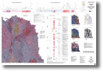
011 - Corryong and parts of Rosewood and Kosciusko 1:100 000 geological interpretation of geophysical features map
 |
| |||||||||||||||||||||||||||||||||||||||||||||||||||||||||||||||||||||||
Product description:Preview map (75 dpi, 1939 kb) Download The downloadable version of this map is supplied in PDF, TIF and georeferenced image ZIP. Bibliographic reference Allen, R.J., 2001. Corryong and parts of Rosewood and Kosciusko 1:100 000 map geological interpretation of geophysical features. Geological Survey of Victoria. Related products:
| ||||||||||||||||||||||||||||||||||||||||||||||||||||||||||||||||||||||||