001 - Ararat and part of Rupanyup 1:100 000 geological interpretation of geophysical features map
 |
| |||||||||||||||||||||||||||||||||||||||||||||||||||||||||||||||||||||||
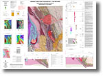
Product description:Preview map (75 dpi, 2459 kb) Download The downloadable version of this map is supplied in PDF and TIF formats. Bibliographic reference Cayley, R.A. & Taylor, D.H., 2000. Ararat and part of Rupanyup. Geological interpretation of geophysical features. Geological Survey of Victoria. Related products:
| ||||||||||||||||||||||||||||||||||||||||||||||||||||||||||||||||||||||||