GSV Report 108 - Heathcote and parts of Woodend and Echuca 1:100 000 map area geological report
 |
| |||||||||||||||||||||||||||||||||||||||||||||||||||||||||||||||||||||||||||||||||||||
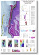
Product description:Download The downloadable version of this report is supplied in PDF format and is a large file (24.5MB). Abstract This report describes the geology of the area covered by the Heathcote 1:100 000 mapsheet 7824, the northeastern part of the Woodend 1:100 000 mapsheet 7823, and the southeastern part of the Echuca 1:100 000 mapsheet 7825. It contains a summary of previous work and gives a comprehensive account of the physiography, geological history, landscape evolution and structural and economic geology, supported by numerous illustrations. The geological and geophysical characteristics of Palaeozoic and Cainozoic rock units are described, and depositional models are suggested for each. A comprehensive list of references is included. Particular emphasis is placed on the lithostratigraphic subdivision of the Cambrian and SilurianDevonian rocks, and on the use of geophysical data to enhance the geological mapping and structural interpretation of the Cambrian rocks. During the Cambrian, submarine volcanism created a package of lavas and volcaniclastics interbedded with oceanic pelagic sediments, which was subsequently buried during the Ordovician by the deep marine quartz-rich turbidites of the Castlemaine Supergroup. The previously poorly differentiated Cambrian volcanic and sedimentary rocks are described in detail, and a new subdivision includes several new formations. Geophysical data are used to extend the surface Palaeozoic geology beneath the younger sediments of the Riverine Plain. The SilurianDevonian marine sedimentary rocks accumulated along the eastern margin of the Gondwana landmass. Mud dominated deposition was periodically disrupted by the influx of coarser grained clastic material during discrete periods of turbidite deposition. These sediments are described and regrouped on the basis of lithostratigraphy rather than the traditional fossil based subdivision. Previously undifferentiated sediments now include the new Waranga Formation, and the previously recognised Broadford and Puckapunyal formations are redefined. The CambrianOrdovician sequence was folded, faulted and cleaved during the Silurian. Some of the Silurian structures were reactivated during the Middle Devonian Tabberabberan Deformation, during which the SilurianDevonian sediments were deformed. During the Late Devonian, granites intruded and metamorphosed the Palaeozoic rocks. The geophysical data along the Heathcote greenstone belt provide a new insight into the structural development of the region. The post-Palaeozoic history is one of successive periods of uplift and erosion (Edwards et al., 1996) related to the tectonic effects of the breakup of the Gondwana landmass, and the development of a sea floor spreading centre between Australia and Antarctica. The formation of the Central Victorian Highlands and the development and subsequent infilling of the Murray Basin are discussed in relation to the regional tectonics and global eustatic and climatic oscillations. Bibliographic reference Edwards, J., Wohlt, K.E., Slater, K.R., Olshina, A., and Hutchinson, D.F., 1998. Heathcote and parts of Woodend and Echuca 1:100 000 map area geological report. Geological Survey of Victoria Report 108. Related products:
| ||||||||||||||||||||||||||||||||||||||||||||||||||||||||||||||||||||||||||||||||||||||