GSV Report 107 - Grampians special map area geological report
 |
| |||||||||||||||||||||||||||||||||||||||||||||||||||||||||||||||||||||||
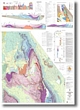
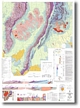
Product description:Download The downloadable version of this report is supplied in PDF format and is a large file (25.0MB). Abstract This report describes the geology of the Grampians ranges and immediate vicinity in western Victoria which includes all of the Grampians 7323 1:100 000 mapsheet and parts of the Ararat 7423, Hamilton 7322 and Horsham 7324 1:100 000 mapsheets. It gives descriptions of the geomorphology, rock units, geological structure and economic geology. Outlines of the regional geological setting, geological history, landscape evolution and a summary of previous geological work and mineral exploration are also presented. Photographs, diagrams, tables and a reference list complement this text. Particular emphasis is placed on the revised stratigraphy of the Grampians Group and the new thin-skinned structural interpretation. The text concludes with an excursion guide designed to show the best exposures which form the basis for the new interpretations. The geology is dominated by strike ranges of Grampians Group which were formed by differential erosion of a thick, deformed sequence of Ordovician to Silurian sandstone and mudstone. The Grampians Group overlies a diverse Cambrian bedrock. The various Cambrian rock types are briefly described and the controls on their distribution and their wider geological setting discussed. The Cambrian bedrock consists of numerous meridional fault-bounded belts of metavolcanics interspersed with quartz-rich low grade metasediments. They constitute the easterly portion of the Glenelg Zone. Outside of the map area, these rocks have been intruded by posttectonic Cambro-Ordovician granites which limits the minimum age of their regional deformation to the Cambrian Delamerian Orogeny. The Grampians Group is a sequence of approximately 3700 m of quartzo-feldspathic to quartzose sandstone and micaceous mudstone in which many new units have been defined. The sediments were probably deposited in structurally controlled basins developed in the Delamerian bedrock, but the age of this deposition is poorly constrained. The Grampians Group may be a fluvial to marginal marine portion of the sediment fan that deposited the Cambrian to Silurian deep marine turbidite sequences of western and central Victoria. The Grampians Group has been tectonically thickened by a series of duplex thrust faults that intercalate and repeat large parts of the stratigraphy. This thickened sequence was then segmented, and transported over the Cambrian bedrock to its present position in a thin-skinned manner along an extensional décollementgiving the Grampians Group an allochthonous relationship to the underlying Cambrian bedrock. The timing of these deformation events is poorly constrained, but they are older than Early Devonian, when the deformed sequence was intruded to subvolcanic levels by several granitic plutons. Contemporaneous eruptions produced the extensive, felsic Rocklands Volcanics in the west. The granites and volcanics are described in detail and have been subdivided into a number of units. There has been considerable and prolonged erosion of the region, with evidence of significant erosion of the Grampians Group prior to intrusion of the granites. However, evidence of the rapid Tertiary dissection seen to the east is notably subdued across the Grampians. The Grampians seem to have been situated on a stable cratonic basement from the Palaeozoic to the present day, and have gradually emerged through this period as a series of strike ranges by the process of differential erosion. A deep weathering profile has been developed on the surrounding low relief surface of Rocklands Volcanics and Cambrian bedrock to form the Dundas Tableland. The numerous types of Cainozoic deposits that fringe the Grampians are described and their origin placed in the landscape history. The Grampians Group has little in the way of economic mineral deposits and is locked within a national park. There is a minor inferred placer gold deposit, and indications of minor gold and copper mineralisation along some faults. The granitic plutons have generated minor hard rock and alluvial gold deposits. Outside the national park the Cambrian bedrock, particularly the belts of metavolcanics, is more prospective for both gold and base metal mineralisation. Some of the Rocklands Volcanics also have potential for gold and base metal mineralisation within zones of hydrothermal alteration. Tertiary marginal marine deposits in the north contain important concentrations of heavy minerals in addition to some recently discovered minor occurrences of brown coal. Bibliographic reference Cayley, R. A. & Taylor, D.H., Grampians special map area geological report. Geological Survey of Victoria Report 107. Related products:
| ||||||||||||||||||||||||||||||||||||||||||||||||||||||||||||||||||||||||