3D geological model of Redesdale and part of Pyalong 1:50 000 map area 2010
 |
| |||||||||||||||||||||||||||||
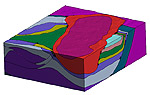
Product description:The Redesdale 3D model was constructed based on geological field observations collected during the mapping of the Redesdale and part of Pyalong 1:50 000 geological mapping project. The model covers an area of approximately 34 km x 29 km and extends to a depth of 10 km. The modelling was constrained at depth by geophysical forward modelling along profiles using ModelVision and targeted inversion of specific anomalies using QuickMag. A number of more comprehensive inversions run in GeoModeller further refined the model using gravity data. One of the primary aims of building this 3D model has been to help understand and also communicate the 3D geology of the mapping area. Software The model was created using Intrepid Geophysics 3D GeoModeller. The 3D GeoModeller software uses primary geological observations, stratigraphic relationships and a sophisticated 3D interpolation to build the 3D model. The interpolated surfaces honour recorded geological contact and orientation data, and provide a prediction of geological surfaces throughout the 3D project area. Triangulated surfaces from the model can be exported in a variety of industry-standard formats, including TSurf files (suitable for import to FracSIS and GoCad), or as web-ready VRML 3D models. Voxel models can also be created. How to use the model To view the PDF of the 3D model you will need the latest version of Adobe Acrobat Reader (Version 9 or later). After opening the model, clicking on the image will enable menus that give you the ability to rotate the model and zoom. You can switch layers on and off via the Model Tree (tab on left side). Download The downloadable version of the 3D model is supplied in PDF format (1.1MB) and 3D data (15MB). Metadata Coordinates Projection: Universal Transverse Mercator (UTM) Zone 55 Datum: Geocentric Datum of Australia (GDA94) Bounding box Map Grid of Australia 1994 (MGA94) coordinates X min 277 648 X max 311 659 Y min 5874 630 Y max 5903 200 Z min -10000 Z max 2000 Input data/model constraints The model is constrained by field mapping, cross sections (some balanced) and potential field modelling. Output model All modelling was performed in GeoModeller Version 1.3-build 161 and output to Adobe Acrobat 9 Pro Extended. Related products:
| ||||||||||||||||||||||||||||||