3D geological fault model of the Glenelg/Grampians-Stavely Zone at 1:250 000 scale 2010
 |
| |||||||||||||||
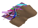
Product description:Introduction The Glenelg / Grampians-Stavely Zone fault model is the precursor to creating a full geological model of the zone. The model is based on 1:250 000 scale serial cross-sections, which were recently released in the 3D Victoria Report 4 (Skladzien et al., 2009). The model is bounded by the Moyston Fault to the east and the Victorian state boundary to the west. The same Moyston Fault surface represents the western extent on the Stawell Zone 3D model. The Glenelg / Grampians-Stavely Zone fault model extends north under Murray Basin sediments to the Victorian boundary and south to the margin of the Otway Basin. Download The downloadable version of the 3D fault model is supplied in PDF format and is a large file (4.1MB). Explanatory notes (440KB), compressed DXF data files (ZIP 5.6MB)and 3D model attributes are also supplied (ZIP 7.7MB). Bibliographic reference McLean, M.A., Skladzien, P.B., Williams, B. & Rawling, T.J., 2010. Glenelg/Grampians-Stavely Zone 1:250 000 scale 3D geological fault model metadata notes. GeoScience Victoria 3D Victoria Report 6. Department of Primary Industries. Related products:
| ||||||||||||||||