3D geological model of the Otway and Torquay Basin 2011
 |
| |||||
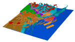
Product description:A 3D model of the Otway and Torquay basins has been produced at 1:250 000 scale as part of GeoScience Victorias state-wide 3D geological model. To date there has been a knowledge gap in the transition between the basement and basin environments. This regional scale integration of the basement and basin models addresses this gap and provides a regional framework within which more detailed work can be carried out in the future. The construction and integration of the basin model has involved both the interpretation and building of new faults and stratigraphic surfaces, as well as utilising existing stratigraphic surfaces and structural interpretations from previous studies, predominantly the Otway Basin HSA SEEBASE project by FrOG Tech (Jorand et. al., 2010). Modelled Faults Numerous data sources were used to interpret a fault network which was subsequently modelled in 3D in GoCAD. Data sources contributing to the fault interpretation:
Where major faults have been named in literature, the names have been used in the model. Where separate fault surfaces were considered part of a fault zone, or as parts of the same fault a suffix of A, B, etc. has been used. Unknown or un-named faults were given an arbitrary number eg. flt_un15. Modelled Surfaces Topography/Bathymetry: Combined topography and bathymetry data held by GSV was used to create the topography/bathymetry surface. Basin surfaces: Basin horizon surfaces were derived from two sources; a set of structurally controlled formation top grids based on seismic horizons re-interpreted by FrOG Tech as part of the Otway Basin HSA SEEBASE project, and GeoScience Victorias energy group formation top grids. The original surfaces have undergone minor modification in GoCAD where overlapping depth values were identified. This involved lowering or raising the respective surfaces within the region of cross-over. Where possible this process was carried out on surface regions identified in the FrOG Tech study as no/poor data areas. Generally surfaces were modified just enough to remove the cross-over, in the order of 50 to 100m, and up to 200m. Where surfaces for a formation have been supplied by both FrOG Tech and GSV, the FrOG Tech surface was used as the primary surface, with the GSV surfaces also included in the model. All Torquay surfaces were supplied by GSV. Primary surfaces: Otway Basin: Top Crayfish Subgroup surface (FrOG Tech) Top Eumeralla Formation surface (FrOG Tech) Top Sherbrook Group surface (FrOG Tech) Top Wangerrip Group surface (GSV) Torquay Basin: Top Eumeralla Formation surface (GSV) Top Otway Group surface (GSV) Top Eastern View Formation (GSV) Top Boonah Formation (GSV) Additional surfaces included in the model: Top Crayfish Subgroup (GSV) Top Pretty Hill Formation surface (FrOG Tech) Top Eumeralla Formation (GSV) Basement: The basement surface used in the model is a SEEBASE surface supplied by FrOG Tech. SEEBASE is a depth to basement model derived from input sources including:
Proterozoic surface: The Protorezoic surface has been interpolated from 2009 Southern Delamerian Deep Seismic Reflection Survey. In the southern offshore region of model area the Proterozoic surface was forced to lie between the Moho and basement surfaces. Faults have been terminated at the Proterozoic surface, however it is likely that some larger basement structures penetrate into the Proterozoic rocks. Moho: The Moho surface used in the Otway Basin model is the Skippy surface resulting from teleseismic tomography. Intrusives Intrusives from the western Victoria granite model have been incorporated into the Otway Basin 3D model, supplemented by five further intrusives modelled in the offshore region of the model. Theses intrusives were derived by interrogating gravity and magnetic datasets (and their derivatives) to outline anomalies interpreted as the response of subsurface intrusive bodies. The intrusive bodies were informed by the shape, size and amplitude of potential field anomalies. References Jorand, C., Krassay, A. & Hall. L. 2010. Otway Basin Hot Sedimentary Aquifers & SEEBASETM Study. Geoscience Victoria 3D Victoria Report 7. Department of Primary Industries. Download The simplified 3D model is supplied as a PDF file (68 MB). The model data is provided as a zipped DXF file (80 MB). 3D model attributes are also supplied (ZIP 7.7MB). | ||||||
