3D geological model of the Walhalla-Woods Point-Tallangallook special map area 2006
 |
| |||||||||||||||
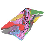
Product description:The 3D geological model is based on the geological maps associated with the Walhalla-Woods Point-Tallangallook geological report. The model covers an area 30 to 50 km wide and 150 km long and extends to a depth of 15 km. The major faults and stratigraphic boundaries have been modelled using GeoModeller and GoCad. One of the primary aims of building this 3D model has been to help understand and also communicate the 3D geology of the mapping area. The model is also being used for regional scale fluid flow modelling in collaboration with the pmdCRC in an attempt to explain the position of the gold deposits relative to the major structures. How to use the model To view the PDF of the 3D model you will need the latest version of Adobe Acrobat Reader (version 8.1 or later). After opening the model, clicking on the image will enable menus that give you the ability to rotate the model and zoom. You can switch layers on and off via the Model Tree (tab on left side). Download The downloadable version of the 3D model is supplied in PDF format and is a large file (4.7MB). Metadata Coordinates Projection: Universal Tranverse Mercator (UTM) Zone 55 Datum: Geocentric Datum of Australia (GDA94) Bounding box: Map Grid of Australia 1994 (MGA94) coordinates Upper left: 388700 E 5914000 N Lower right: 458000 E 5780300 N Input data/model constraints The model is constrained by field mapping, cross sections (some balanced) and potential field modelling. Output model Surfaces modelled in GeoModeller were exported as T-Surf format and imported into GoCad. The final model has been taken from GoCad and converted via Adobe Acrobat 3D 7.0.7 into a PDF. Related products:
| ||||||||||||||||

