Map 6 - Ballarat Deep Leads (Sheet 1 of 2)
 |
| |||||||||||||||||||||||||||||||||||||||||||
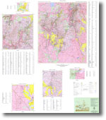
Product description:Download The downloadable version of this map is supplied in PDF, TIF and ZIP formats (georeferenced image).Map 6 - Ballarat Deep Leads (Sheet 1 of 2) is a 1:100,000 scale map accompanied by the following enlargements: Rokewood District - 1:25,000, Berringa Gold Field - 1:25,000, Pitfield Plains District 1:25,000, Sago Hills 1:25,000 and Scarsdale District 1:5,000. This map sheet is a companion product to Map 6 - Ballarat Deep Leads (Sheet 2 of 2) Bibliographic Reference Finlay, I.S., Plier-Malone, E.N.M., Cochrane, R.M., Bucknall, M., Douglas, P.M. & Caluzzi, J., 1992. Ballarat 1:100 000 deep leads and mines. 1:100,000 Deep Leads map 6, sheet 1. Geological Survey of Victoria. Related products:
| ||||||||||||||||||||||||||||||||||||||||||||